
Gardens of the World
There was an advertisement on T V in New Zealand in the 1990s that had the headline “Don’t leave town until you’ve seen the country”. It was to encourage Kiwis to visit their own country before venturing overseas (we are surrounded by ocean down here at the bottom of the world).
Well, it seems that the world has come to New Zealand. A week ago we visited the Hamilton Gardens in the Waikato city of Hamilton. The garden there are quite unlike most other municipal gardens in New Zealand. Instead of the usual beds of plants and flowers laid out in the traditional English or European fashion, these gardens are set out in distinct themed country areas.
With only two weeks to go before our on trip “overseas” the visit to the gardens was timely. We would like to share images of our visit with you.

Cloistered Courtyard with fountain

Gate to Chinese Scholars Garden

Reflections

Entry to Japanese Garden of Contemplation

Dovecote in the English Flower Garden

Marilyn (Modernist American Garden)

Indian Char Bagh Garden

Indian Char Bagh Garden

Arched Trellis walk leading to the Italian Renaissance Garden

Central dome in the Arched Trellis Walk

Italian Renaissance Garden

View to Italian Renaissance Garden

Te Parapara Maori Garden with Kumara (sweet potato) mounds

English Tudor Garden

English Tudor Garden
Go North Turn Left
With our pending three month journey to Europe and North America about to begin in just under two weeks, my wife Valerie and I have established an companion blog to this one called Go North Turn Left. In this blog we will relate tales of our travels (hopefully not travails) as we venture forth on the various legs of our journey.
So, where did the blog name come from?

We have a very dear friend who believes that everything in the world is up and to the left of New Zealand. Her view of the geography of the world dates back to primary school days when she first looked at a map of the world. On that map New Zealand was at the bottom right corner. This view of the world has always intrigued us, especially Valerie who was a former geography teacher. So, to honour this unusual view we have named the blog “Go North Turn Left”
Our travels this year start at the end of July 2013. We trust you will enjoy the journey with us.
Posts will also continue here as time and internet connections permit.
The end is in sight!

The last six weeks have been a trial. In February we sold our home of the last 32 years. We built it then to replace the home that my wife grew up in until we were married 44 years ago. Thirty two years of raising three sons and accumulating life’s possessions, plus those possessions that flowed out of the old house, have made the last few weeks difficult at times as decisions needed to be made on to what to keep and what to re-house elsewhere. Yesterday we left the house with just three small cartons to top-up and close. Our life is now housed in a storage facility awaiting rediscovery when we find a new home some time in the next year. Finding a view of the end over the last two weeks has been difficult, but yesterday it emerged.
In two weeks we leave for a three month holiday that will take us to China, Europe, the USA and Canada. Needless to say, we are really looking forward to the adventure. Just like the last few weeks, transmission over the next three months may be a bit patchy as we search for internet connections and time to update posts. Every attempt will be made to create a regular stream of posts and express views on what we discover.
Piebald Skies
If ever I am called to go to another town or city for pleasure of for business I try to get out for an early morning walk. For me, it’s the best time of the day. It’s the time before most people begin to move, and the time when the light is clear, the sun is still low, and the air is fresh.
It was on such a morning that I took my morning walk along the coastal walkway at New Plymouth in the Taranaki region of New Zealand. Taranaki occupies that area of the large western cape of the North Island of New Zealand. Its central feature is Mt Taranaki, a Fuji look-alike that dominates the landscape throughout the region. The coastal walkway stretches 11 km from the Port Taranaki, past the New Plymouth CBD, then on around the cliffs and beaches in a northerly direction. It’s popular with walkers, runners and cyclists.

Fitzroy Beach from the New Plymouth Coastal Walkway

Resting and viewing area beneath the cliffs just north of the New Plymouth CBD

Port Taranaki and New Plymouth CBD. The “wand” on the foreshore next to the rectangular white building is an installation art piece designed by artist Len Lye.
On this particular morning there was a lovely piebald sky that added to the enjoyment of the walk.
Fireflame Chillies
I love street markets, no matter where in the world they are. Its the combinations of colors, activity and people that make them so fascinating. Here is a selection of images taken at the Matakana Market, a farmers’ market held during the summer at Matakana Village, an hour’s drive north of Auckland.

Fireflame, that’s on medium please!

“Now you need to understand some of the finer points about chillies”

“Which one would you like to try first?”

You’ll need to visit Puhoi to see the “Big Cheese”

“And now for a we spell to turn this into the perfect organic crepe”

Why can’t I grow basil like that?

“This, Monsieur, is the perfect pastry for you”
Now Closed … Sorry for any inconvenience

Well, that’s what the sign said! Clearly this wasn’t the case on the day of our visit to the Matakana Market. Perhaps the sign had been turned around?

How about some organic beans, or spray-free tomatoes? This is a farmers’ market afterall, and we have t cater for all tastes.

Baby Royal Gala apples as well, you know, the ones on the bike! Or is the man on the bike chasing the apple? But, I’ll take some special capsicums, please. And is that pumpkin $4, or is it Number 84?
Market Minstrels
Because I haven’t had much time lately to get out and photograph anything, because of packing our house full of belongings into a storage unit, so I have revisited my library of images to get inspiration for posts. The next few posts will contain images taken at the Matakana Market located about an hour’s drive north of Auckland. The farmers’ market runs on Saturdays through the summer months and attracts large numbers of visitors from Auckland and the surrounding district, especially from the holiday homes at the nearby beaches.
One of the features of the market is the small group of musicians who play there during the opening hours to entertain shoppers. Occasionally they leave their “stand” and wander through the market. Here are a couple of images of the market minstrels.

Free Range Eggs

Evening Sky

There are some evenings when you just have to go for a walk. The day on which this image was taken had improved markedly after a late summer storm so we decided to take a walk around the rocks and along the base of the cliffs at the end of Takapuna Beach, near where we live. An added incentive was the expected departure of a cruise ship from Auckland which carried some friends as passengers. We hoped to watch the ship sail out through the channel that lies between the beach and nearby Rangitoto Island. Fortunately the tide was well out that day, because after waiting until well after the expected departure (the ship didn’t sail because of engineering problems) we had to make our way back to the beach in far distance before the tide would force us ti climb over the rocks. As we turned to head home we were presented with this view to the Takapuna township and beach, and the evening sky reflected in the wet sand.
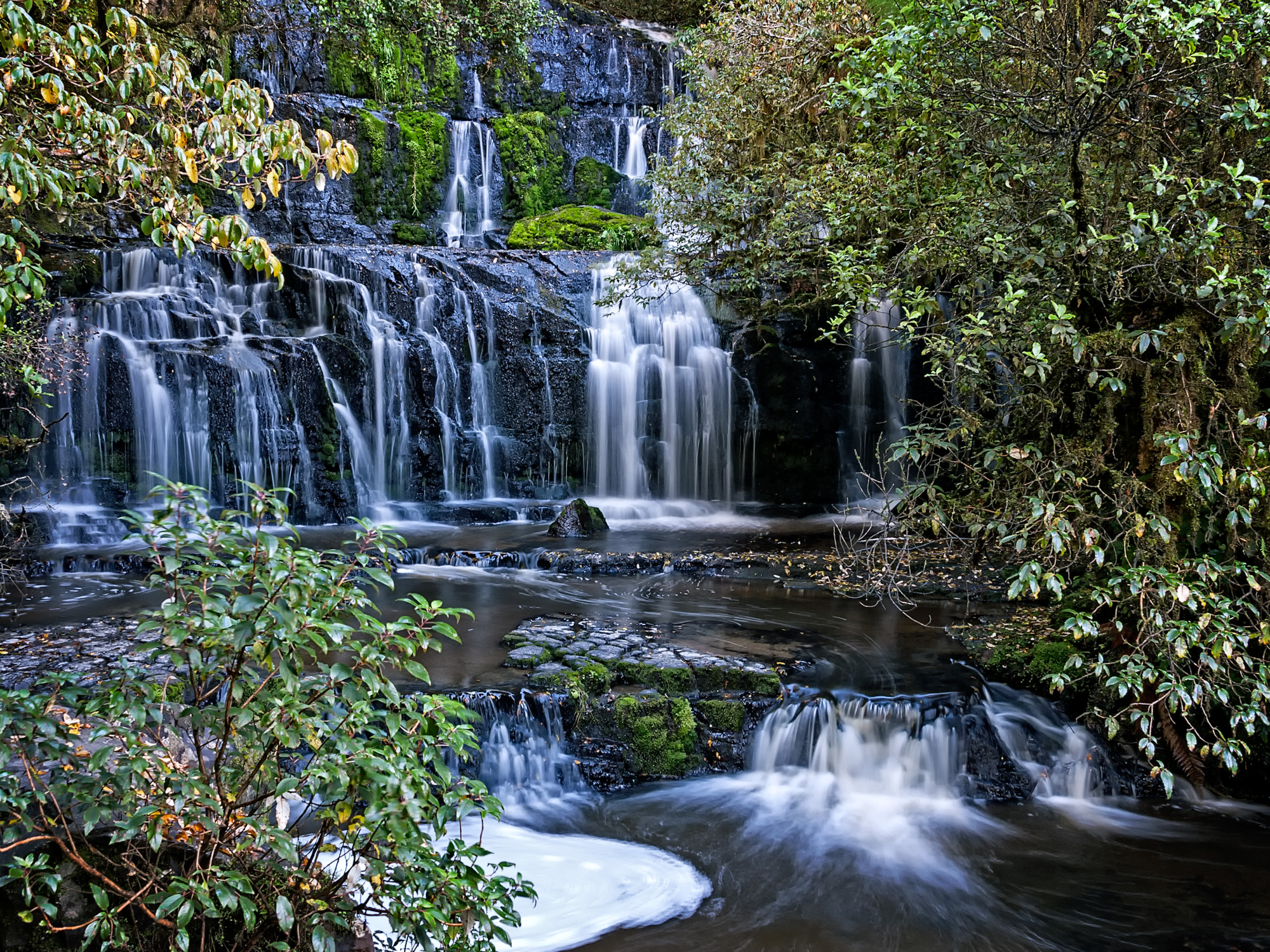
Purakaunui Falls Revisited
Some time ago I posted an image of the Purakaunui Falls that I took on a trip to the Catlins in the Southland region of the South Island of New Zealand. That image was taken on my second visit to the falls, the first visit being when in the early 1980s we took our (then) three young sons on a touring holiday of the South Island. Both visits were prompted by a photograph we had seen of the falls that appeared in a calendar, I think, which was taken by the well known New Zealand landscape and nature photographer Craig Potton. The striking thing to me back then was how Craig had captured a silky looking waterfall in his image. At that time I had no idea how he had made the image, but over the years I too learned how it is done.
Since that first post I have been wanting to revisit the image and render it differently, and maybe add another view of the falls as well. So, here is take two.

Explorer – Definitely not a do-up!
On the opposite coast and further north than Dargaville, that featured yesterday’s post, is the Manganui Harbour (or Harbor if you live in North America). On my morning walk on the day after finding the “do-up” at the Dargaville Museum I saw this beautiful craft being readied for the day’s voyage.

The launch “Explorer” was immaculate, and the owner clearly very proud of his vessel. It had lovely classic lines and was painted in appropriate colors to match the style. For me it was love at first sight! The other more modern and “flasher” designs in the harbor didn’t stand a chance. This was a vessel to be loved and cherished. It took all my efforts to drag myself away from admiring this thing of beauty. I have no desire to own such a craft, but given half a chance I would leap at an opportunity to go aboard and take a cruise. So much for dreaming. It was nice while it lasted!
Do-up Job

Behind the pioneer museum in the Northland town of Dargaville is a yard that contains a number of projects awaiting attention.
The Dargaville Museum has exhibits that tell of how the district has developed through the years, from a 16 metre long pre-European Maori canoe through to the newly built replica gumdiggers camp, from shipwreck relics recovered from the coast to the masts of the ill-fated Greenpeace protest ship Rainbow Warrior. It makes for an interesting visit to get a flavor of the Northland district before venturing further north.
The “exhibit” that caught my attention though was the old working boat “Cutter”, clearly in need of a bit of TLC (tender loving care). She looked quite forlorn sitting in the back lot among miscellaneous other discarded items. For all that, she still had a worn dignity that comes from years of honest hard work.
Puheke
The Karikari Peninsula is at the northern end of Doubtless Bay in the Northland region of New Zealand. Doubtless Bay was named by Captain James Cook who said, apparently, “Doubtless a bay” in 1769. It’s a large sweeping bay with a 14 km white sandy beach, a holiday makers’ and anglers’ paradise. The beach ends where the Karikari Peninsula begins.
Almost directly opposite and on the northern coast of the peninsula is a pimple of a mountain named Puheke. Because the surrounding area is flat, this tiny mountain takes some prominence in the landscape. The short climb to the top produces wonderful views of the surrounding area, including that of another sweeping white beach bordering Rangaunu Bay to the northwest. Appropriately, this is named Puheke Beach.

Puheke Beach

Mt Puheke, with trig station and a Maori carved wooden Pouwhenua (land post)
Close to the foot of Puheke is is the small reedy Lake Rotokawau.

For years the Karikari Peninsula has been a favorite holiday spot for many New Zealand families who seek both beauty and solitude, with plenty of fishing, of course! During the 1950s and 60s many of the holiday “homes” were mere cottages, often unlined and without electricity, a connected water supply, or formal sewage system. Tank water sometimes ran out in long hot summers and a new toilet pit had to be dug every few years, necessitating a moving of the “little house” to a new location. That’s how it was when we first holidayed in “The Far North” in the early years of our married life. In more recent years the holiday home have acquired a few more comforts, along with electricity.
Old Work Horses
Well, not the kind you were likely thinking of perhaps. Outside the entrance to Gumdiggers’ Park, just north of Northland’s northern-most town Awanui, are two old mechanized work horses – a tractor and a truck. Gumdiggers’ Park is a small museum and outdoor display dedicated to the digging of Kauri gum.

Tethered
Kauri gum is formed when resin from Kauri trees leaks out through fractures or cracks in the bark, hardening with the exposure to air. Lumps commonly fall to the ground and become covered with soil and forest litter, eventually fossilizing. Prior to European settlement the indigenous Maori used the amber-colored gum for chewing, fire lighting, jewelry, and as the basis for a pigment used in tattooing. European settlers soon found that the gum mixed easily with linseed oil to make an excellent varnish, and from 1910 Kauri gum was used extensively in the manufacture of linoleum. A lucrative trade started in the 1890s and continued until the 1930s when synthetic substitutes came into use. In the late nineteenth and early twentieth centuries transient workers fossicked in areas where old Kauri forests once stood, often in swampy ground, seeking out hidden gum deposits which they sold at quite low prices to gum merchants. My own grandfather worked in the gum fields of Northland when he first landed in New Zealand in the first decade of the twentieth century.

Getting back to the mechanized work horses. Although they are outside Gumdiggers’ Park, they are unlikely to have been used in the gum digging industry described above. Because of their age, they are more likely to have been used in the recovery of “Swamp Kauri” i.e. old fallen logs which are hauled out of the swamps where they had been preserved by swamp water for use in furniture manufacture and souvenirs of Northland.
For me, these two vehicles were as interesting as the exhibits inside the park, especially because of the late afternoon lighting.
“King Bill’s” Hall
Just south of Rarawa Beach is the small settlement of Houhora. When I first visited Houhora in my youth I was able to visit the Wagener Museum, which housed an eclectic collection of artifacts relating to the early settlement of the district in an old stables building. Sadly the museum burned down In the 1980s and some of the collection was lost. The remainder of the museum closed in 2003, but a down-sized version has since reopened. The old museum was a great place to visit and was known to many Kiwis of my age (that’s telling you a bit!).
Not far from the old museum, and next to the Houhora Pub, are several old buildings that have fallen into disrepair but have a strong local historical interest.

One of them is the old hall which was owned by “King Bill”. “King Bill” Evans was a trader, publican, land owner and general entrepreneur in the 1890s. The local hall was a centre of activity in those days and was variously used for meetings, dances, weddings and church services. Today it is slowly rusting away in the field near the pub.

“Air conditioned, with views of the sky”
These images were taken in the late afternoon as the sun was sinking towards the horizon in the west. Click on images for a larger view.
Rarawa
There has been a bit of a lull lately. After 32 years living in our present house we are now packing our lives into boxes as part of the moving on process. Consequently, there hasn’t been a lot of time for making new posts. So here is something to keep the flow going.
Several years ago we took a short break with some friends in the far north of the North Island of New Zealand. The Northland region is all that area north of and including the City of Whangarei. Apart from Whangarei and a couple of other small regional centres, Northland is sparsely populated. Industries in the region are mainly farming, forestry , fishing and tourism. It also has some wonderful beaches that attract campers in the summer holidays, but are left in solitude for the rest of the year.
Rarawa Beach is one.

Rarawa Beach is a 55 km drive north of the second largest Northland town, Kaitaia. The white sandy beach is about 2 km in length between rocky headlands at either end. A small stream cuts a meandering path across the beach to the surf . It’s not hard to find that you have the beach all to yourself.

And that’s how we found it on the day of our visit. Just an idyllic place to be. Click on images for a larger view.
No, it’s a dog!

It’s interesting how we humans try to see shapes of things we know in the features that nature present to us. Does that cloud look like a bird? Or, that mountain looks like Queen Victoria lying in state, you can tell by the nose. Here at Punakaiki the shape that nature presents to me is a dog, but you may see something else.
Punakaiki is on the road between Westport and Greymouth (or is that between Greymouth and Westport, because it is closer to the former?) and is a geological feature of stratified rock formations created more than 30 million years ago. The feature is known as the Pancake Rocks. That’s not unusual really. There’s that shapes in nature thing again.

Punankaiki is actually the nearest village to the rock formation at Dolomite Point in the Paparoa National Park. The pancakes are formed from minute fragments of dead marine creatures and plants that landed on the seabed some 2 km below the surface. Immense water pressure caused the fragments to solidify into hard and soft layers. Gradually seismic action lifted the limestone above the seabed and mildly acidic rain, wind and seawater sculpted the bizarre shapes seen today.

In wild weather, which is very common on the West Coast, the blowholes that form part of the Pancake Rocks are said to be spectacular. Unfortunately in all the visits I have had to the area over the years I have never seen them in action in any serious way.

The rocks rare are a very popular West Coast tourist attraction and on a good day the walking paths provided and maintained by the Department of Conservation are busy with people trying to get the best views.
I still think its a dog!
Boom Town
It is hard to envisage in 2013 that the Westland town of Hokitika was once one of the most important towns in New Zealand. Today its economy relies on the surrounding dairy farms that feed the Westland Cooperative Dairy Factory, and tourism-based ventures. In 1866 however, Hokitika was the second biggest town in New Zealand after Auckland. Gold had been discovered on the West Coast in 1864 and the town grew rapidly as people flooded into the area to seek their fortunes. On one day in 1867 it was reported that 41 vessels were tied up at the Hokitika wharf, with more waiting off shore. How times have changed.

Ever since my first visit to the town way back in the 1960s I have been fascinated by the connection of the town with Andrew Carnegie. How could this rich American philanthropist have become aware of and have an interest in this far-flung isolated town in a distant corner of the southern Pacific Ocean? On a corner, one block away from the main street of Hokitika, is a grand building with “Free Public Library” emblazoned across the frieze above the columns at the entrance. It’s in that sign that the connection is made.
Andrew Carnegie made his fortune in the iron and steel business. While still a boy working in his father’s cotton milling business, he and other boys working in the mill were granted free access the library of a local businessman. Carnegie became an avid reader devoured most of the 400 books in the collection. After he sold his steel milling business to banker J P Morgan in 1901 for $200 million, he set out on his philanthropic endeavors. In recognition of the help received from free access to books in his youth, Carnegie established a grant system to assist towns and cities in the English-speaking world to build library buildings on condition that access to and lending of books was free. Eighteen such libraries were built in New Zealand, including the one in Hokitika which was opened in 1908.

The building ceased to be a library in April 1975. It was later restored and reopened in May 1998 as home to the West Coast Historical Museum. So that’s how Andrew Carnegie came to be connected to the West Coast of the South Island of New Zealand.
In researching for this post I discovered another interesting fact about Hokitika. It has a digital 3D cinema, in a town with a population of just 3,078 (2006 census), plus another 828 people in the surrounding district. The Art-Deco Regent Cinema was built in 1936 and has served the town ever since. When in 1975 it was threatened with demolition due to its state of repair and lack of patronage, a group of concerned citizens lobbied for its retention and formed a trust for its preservation. Funds were raised to refurbish the building back to its Art-Deco heritage style and it has been turned into a successfully functioning cinema again – a digital 3D cinema to boot.

So there you have it, a boom town of the 19th century is booming again in the 21st century (albeit in a much different way).
Rugged Westland
Coastal Westland is a pretty rugged and sparsely populated place. Between Haast in the south and Hokitika in the north there are few towns and a thinly spread population.
“The District consists of a long thin strip of land between the crest of the Southern Alps and the Tasman Sea. The low-lying areas near the coast are a mixture of pastoral farmland and temperate rainforest. The eastern part of the District is steep and mountainous. Many small rivers flow down from the mountains.
The southern part of the District notably contains the Franz Josef and Fox glaciers.
Westland is one of the most sparsely populated parts of the country, with an area of 11,880.19 square kilometres and a population of 8,403 people (2006 census). Approximately 45% of the population lives in Hokitika (popn.3500). The remaining 55% lives in small villages such as Ross, Franz Josef and Haast, or in rural areas”. Wikipedia
From Wanaka we travelled beside Lake Hawea and over the Haast Pass to reach the West Coast at the mouth of the Haast River. Our destination for the night was Fox Glacier Village, from where we planned to visit the nearby Fox and Franz Joseph Glaciers.

Some 25 km north of Haast is the Arthur’s Point lookout from where views of the Tasman Sea and the coastline can be seen.
In the year I left high school I hitch-hiked around the South Island of New Zealand with a friend. It was almost a right of passage between high school and university. We had travelled down the West Coast to Lake Mapourika, which at the time was almost the end of the road. To join up with the road from Haast to Wanaka we had to walk the newly formed but far from finished section of the road from the lake to Arthur’s Point, a distance of about 10 km in wet sticky mud. In the distance we could hear heavy road building machinery. As the time ticked far too slowly towards “knock off time” of 5.00 pm we were afraid we would miss any chance of a ride to Haast and have to sleep the night in the bush. At last gasp we reached the work party just as they were packing up to leave for the night. Happily we flopped onto the back of a truck for the final leg of the day’s journey.
Heading north from Arthur’s Point the road travels inland for a distance before touching the coast again at Bruce Bay, a rugged pebbly beach strewn with driftwood. If you like rugged storm-lashed beaches, this is the place to be. It was fine on the occasion of our visit, but it is easy to imagine the chaos when a south-westerly storm is raging – cold, wind-blasted, with wild surf and horizontal rain!

At the northern end of the bay the trees stand defensively against the weather, stripped of their lower branches and clinging to the eroding boundary between land and beach.

You have to be hardy to live in these parts. It’s little wonder that the coasters have that steely weather worn look that comes from living everyday with the elements.
Click on any image for a larger view.
Rest Home

On the high road between Queenstown and Wanaka over the Crown Range is the small settlement of Cardrona. To reach Cardrona from Queenstown one has to drive through two sets of switchbacks to reach the summit before descending through the Cardrona Valley to the village. For first-time drivers on this section of road, it is quite an experience. There are several lookout points along the road that give great views back towards Queenstown and Lake Whakatipu, and across the valley to the Remarkables (a jagged mountain range that is a feature of the evening view from Bob’s Peak in Queenstown).
Cardrona has a pub that is a mecca for skiers after a hard day at the nearby Cardrona Ski Resort. Established in 1863 and still bearing its original wooden facade, this character pub once featured in a TV commercial for a well-known Southland beer. While some gather in the bar to drink their apres ski beers, many migrate to the garden to sit at picnic tables or huddle around the outdoor open fireplace to recount their day and enjoy a gluhwein or two.
On the far side of the garden an old blue Model T Ford truck rests at home in a tumble-down shed. It looks the part in these surroundings, which are rather laid-back. It all adds to the character of what a visit to the Cardrona Pub is all about.
Daisies at the Lower Reaches
Imagine for a moment the letter “S”. Now stretch it horizontally until the connection between the upper and lower arms of the S is almost vertical. and then rotate it 90 degrees to the left. It now looks a bit like a fork of lightning. Are you still with me? That is the distinctive shape of Lake Whakatipu in Central Otago’s “Lakes” region. Imagine then that the popular tourist town of Queenstown is near the corner of the zigzag before the vertical drop.
This image was taken near the southern end of that vertical drop.

The southern arm of Lake Whakatipu “below” Queenstown is known as the Kingston Arm, named after the small town that used to be the terminus for the railway line from Dunedin. Kingston is also the place where the famous lake steamer TSS Earnslaw was brought in parts, assembled and launched . The Wikipedia account of this remarkable story is shown below:
“At the beginning of the twentieth century, New Zealand Railways awarded 21,000 pounds to John McGregor and Co shipbuilders of Dunedin to build a steamship for Lake Wakatipu. TheEarnslaw was named after Mount Earnslaw, a 2889 metre peak at the head of Lake Wakatipu. She was to be 48 metres long, the biggest boat on the lake. Transporting the Earnslaw was no easy task. When construction was finally completed she was dismantled. All the quarter inch steel hull plates were numbered for reconstruction much like a jig-saw puzzle. Then the parts were loaded on to a goods train and transported across the South Island from Dunedin to Kingston at the southern end of Lake Wakatipu.
Six months later, after being rebuilt, on 24 February 1912, the TSS Earnslaw was launched and fired up for her maiden voyage to Queenstown, with the Minister of Marine as captain.”
She then became a valuable vessel for the New Zealand Railways (NZR) and was known as the “Lady of the Lake”.
But that’s another story.
It was late in the afternoon as we approached the lake from the southern end. After stopping briefly at Kingston to look at the “Kingston Flyer” steam train (sadly mothballed at the time), made famous in the 1980s in a TV chocolate advertisement, we recommenced our journey to Queenstown. Just as the lake came into view we were presented with this field of daisies between the brown seeding Dock weeds. It was the contrast between the white of the daisies and the green and brown of the pasture that first caught the eye. The slopes of Mt Dick fall to the lake on the left of the image, and in the distance the Remarkables drop to the lake on the right. Queenstown is around the corner to the left at the far end of the view.
Let the River Run
A small distance from the eastern portal of the Homer Tunnel as you head towards Te Anau is a road on the left that leads to the Homer Hut and the start of the Gertrude Saddle track. Just after entering of the road is a car park beside the upper reaches of the Hollyford River. At this point the valley is quite wide. Further downriver the the valley narrows markedly and the river runs more swiftly. The Milford Sound Highway follows the river before the road veers away to pass through “The Divide” between the Darren and Livingstone mountain ranges.

This image was taken from the car park on the Homer Hut Road. At this point the flow is quite placid. The river flows from the Gertrude Valley (out of picture to the left) and follows the main Milford Sound Highway for some ten kilometers before the road turns towards Te Anau.

Side streams enter the flow all down the river, especially after heavy rain. There is no vegetation to retain the water on the mountain slopes so there is only one way for it to go – down. As the water dissipates after a storm many of the side streams dry up until the next deluge, as has happened here. This view is directly behind the one above.
 Several kilometers down the road the mood of the river changes markedly as rapids impede the flow. It now looks like the kind of mountain river that reflects the looming power of the steep mountains that feed it. After heavy rain the water powers through the narrow valley and rages over the rapids. All obstacles are swept away. All that can be done is to let the river run.
Moody Mountains
As anyone who has traveled to Milford Sound in the Fiordland National Park on the southwestern side of New Zealand’s South Island will know, the further up the Hollyford Valley you travel, the steeper the surrounding mountains get. They loom above you as you approach the famous Homer Tunnel. In winter this road can become impassable because of snow avalanches cascading down the near vertical mountain faces. In spring, as the snow thaws, rock avalanches can also close the road as a result of ice shattering rock during the winter freeze.
This extract from from the New Zealand topographical map of the area clearly shows the gradients of the surrounding mountains. (Click on link for larger view)

It was at the eastern entrance to the Homer Tunnel that these images were taken. The tunnel is the only way through the mountains to reach the Milford Sound by road. Entrance to the tunnel is controlled by traffic lights as there is just a 1.2 km single lane road through the Darren Mountains at the Homer Saddle. Until 1954 there was no road access to the Milford Sound.


On the day we left Milford Sound via the Cleddau Valley and through the Homer Tunnel it became more overcast as we climbed further into the mountains. By the time we reached the tunnel it was threatening to rain and the temperature had dropped considerably. As we exited the tunnel and into the beginning of the Hollyford Valley we were presented with these views.
Luxmore Grunt
Let’s get it out up front. Some people are masochists; either that, or plain stupid (or more kindly – very determined)!
We had heard of the famous “Luxmore Grunt” from friends who do lots of walking whenever they are on holiday. I wouldn’t call them serious hikers (or trampers, as they are commonly known in New Zealand), but keen day-walkers. They keep a book listing all their completed walks, which they respectfully call their “Alzheimers Book” in case they forget which walks they’ve done.
The “Luxmore Grunt” is a mountain running event sponsored by the Asics sports shoe company and is run each year in December. The full race runs over the complete 60 km of the Kepler Track (another of New Zealand’s “Great Walks”), a circuit that starts and ends at the control gates outlet of Lake Te Anau. Part of the track between Brod Bay on the lake shore and the Department of Conservation operated Luxmore Hut is normally a 4 1/2 hour, 8.5 km one way walk, and part of that rises from lake level (210 meters) to the hut at 1085 meters, the first 3 1/2 hours of which is steeply uphill. The course record for the full 60 km Kepler Challenge is 4:37:41 for men, and 5:23:34 for women! For the Luxmore Grunt from the control gates to Luxmore Hut and back (27 km) is 1:52:30 for men, and 2:04:18 for women!
With only part of this knowledge available we set out to walk the return trip to Luxmore Hut, on the day after dropping our son and his wife at the start of the Routburn Track. Starting at the Lake Te Anau control gates at 9.45 am we thought we had plenty of time to complete the walk, given the long evenings experienced in this part of the country during summer.

Following the lake shore we made our way to Brod Bay which, according to the walking guide was a gentle hour and a half walk through forest of mountain and red beech. The problem when two people walk with cameras is that time gets stretched out – one and a half hours turned into two.

Knowing we had a steep climb ahead of us, we stopped for an early lunch to fuel us for the next stage of the walk. With energy levels duly topped up we set out on the climb, gentle at first, but then into an unrelenting 750 vertical meter grind. About one third of the way into the climb we glimpsed a view of the Te Anau township across the lake through the trees.

Onwards and upwards for another hour we reached a limestone bluff, a suggested lunch stop in the walking guide. Having already eaten lunch, we stopped anyway for a drink and some trail mix. Hikers making the downward journey informed us there was still another hour before the track cleared the treeline, so back into the grind we trudged.

Finally, four and a half hours after leaving the car we emerged from the forest onto alpine meadow-land. The immediate reaction was one of relief. After catching breath the scenery came into focus.

There before us were panoramic views of the Te Anau Basin, Takitimu Mountains, and the Snowdon and Earl Mountains. We never did reach Luxmore Hut. It was another 45 minutes further up the hill. That didn’t really matter as we achieved what we set out to do, which was to get a high alpine view of the lake, township, and surrounding mountains.
Being late in the afternoon we needed to commence our return journey after only a short rest.
Long stretches of downhill walking are very tiring. After a long day of walking legs turn to jelly. It was tempting to stop on reaching Brod Bay, but we were still ninety minutes away from the car. Switching to auto-pilot and brains into neutral we stumbled our way to the car park and collapsed into the car, ten and a half hours after setting out. Back to the motel we drove, dived into a hot bath, grabbed some food for a quick dinner and fell into bed, exhausted!
The Luxmore Grunt had lived up to its reputation.
(Click on images for a larger view)
Rain Forrest
After dropping our intrepid walkers at the start of their rain-soaking three day walk of the Routeburn Track, we decided to have a walk of our own before setting out on the journey to Te Anau. At the end of a small gravel road near the Routeburn Shelter there is a swing bridge that marks the entrance to the Sylvan Lakes Track. The rain was steady, but light as we set out across the bridge. Already swollen from the overnight rain, the river below the bridge heaved its way over boulders in the river bed in a tumultuous journey towards Lake Wkakatipu.
As we entered the rain forest the rain began to get heavier. The ground underfoot was already soaked with water and the track had become an endless series of puddles connected by islands of slightly higher ground. It was no use trying to keep your boots dry – may as well splash on regardless.

A walk in a rain forest, in the rain, is magical. Overhead the green canopy glistens and the moss on the ground is almost luminescent against the fallen and decaying leaves on the forest floor. Wetness turns the tree trunks almost black, speckled with green lichens clinging to their bark.

Scattered across the forest floor are branches that have fallen as a result of past storms, now decaying and acting as host to more lichens and mosses.

Thunder was starting to clap overhead and the rain became even heavier. Camera gear was getting wet. The temperature was dropping. It was time to retreat and head back to Glenorchy and a nice cup of hot coffee and a bite to eat.
(Click on images for a larger view.)
